August 22nd and I am in Knox County, Ohio, about an hour northeast of Columbus. My starting point today is Mt. Vernon, a very bike-friendly town, with an awesome welcome center.


My plan today is to complete the Knox Co. “Hat Trick” by riding the Heart of Ohio, Kokosing Gap and Mohican Valley Trails. They are all basically inter-connected trails which lie on the former Pennsylvania Railroad line. I have covered the Kokosing and part of the Heart of Ohio before while riding the “Pan Ohio Hope Ride.” I have brought my Fuji gravel bike as I am not sure of the conditions on the Mohican and parts of the Heart of Ohio.
I start out by riding southwest out of Mt. Vernon on the Heart of Ohio trail, which extends about 2 miles SW of Centerburg, about 15 ½ miles from Mt. Vernon. As the trail moves out of downtown Mt. Vernon I pass the truly spectacular Ariel Foundation Park. This park has become a community focal point and a unique trailside stop. The park is a reclaimed manufacturing area with walking trails, community center, 3D landscaping sculptures and an observation tower, which is a must (be careful in your cycling shoes).

")


Just outside of Mt. Vernon the trail moves alongside a drag strip. The trail is wide and well maintained, and the traffic light as it is a Wednesday afternoon. The temperature is 70 degree and I have a modest headwind. The trail goes from canopy to countryside and back several times. The halfway point is Mt. Liberty. There’s a small parking lot with a shelter. Just before you reach Centerburg, you will see the marker below (highest point on the trail).

This reminds me, there are trail mile markers posted along the way.

After passing thru Centerburg, you will cross a nice, newly constructed pedestrian bridge over US 36/Ohio Rt 3, after which you come to the end of the pave section of the trail. The Heart of Ohio Trail is part of the Ohio-to-Erie Trail system as well. I make the turn and head back to Mt. Vernon, crazy as it gets, the wind has shifted and a have another headwind.
")


Part II.
I top off my water bottles and use the nice facilities at the Mt. Vernon welcome center. Cross Main St/State Rt 13 and you are at the trail head of the Kokosing Gap Trail. Very picturesque bridges nearby for a photo opt before I shove off northeast towards Danville.

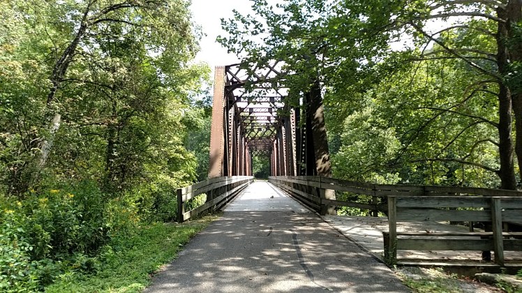
The Kokosing Gap Trail is a well paved, approximately 14-mile stretch from Mt. Vernon to Danville. Like the Heart of Ohio Trail, it lies on the former Pennsylvania Railroad line. Farms, forest and Kokosing River views are a aplenty. There are a number of river crossings on several rail-converted-to-pedestrian/bike wooden-decked steel bridges, two of which are more than 250 feet long, and impressive high steel construction, worth a photo opt.
A 1940 Alco 0-6-0 locomotive and a 1924 Chesapeake & Ohio caboose are trailside as you roll into Gambier, home to Kenyon College. Also found this funky piece of artwork, for a bike-selfie. The sandstone underpass bridge in Howard is also worth stopping for a closer look.


Water and restrooms can be found on the tail in Mount Vernon, Gambier and Howard. In Danville, facilities are in Memorial Park, next to the football field. For Pan Ohio riders, you will know this park as the “Subway Lunch Stop” location. Park benches are located along the trail along with trail mile markers every 1/2 mile.

As I exited the trail in Danville I came upon a person walking and asked for direction to the “Bridge of Dreams” and the Mohican Valley trailhead. She kindly pointed me in the right direction. There are signs indicating the Mohican Trail (just NE of the large grain silos in Danville’s downtown area).

Part III
The Mohican Valley Trail is about 5 plus miles from Danville to the Holmes County line. Based on my timelines, I probably needed to turn around, but I really wanted to check out the bridge. I hadn’t done much research on the trail other than general location and distance. I wasn’t sure on surface condition and that is why I was riding my gravel bike. The Heart of Ohio and Kokosing Gap would have been fine with my Cannondale road bike and surely would have rolled faster with less energy, but that’s the way it goes.
As I started down the trail, you quickly find that it gets a lot of buggy traffic from the local Amish community as there are “road apples” everywhere. The surface is tar and chip,10-12 feet wide, loose gravel in some spots, so good call on the gravel bike. I sense a slight decline in elevation as I ride east/northeast. No mile markers to speak of, feeling of being very remote. The 370′ long Bridge of Dreams is about 4 miles out of Danville. The bridge was transformed from an old 1920 rail bridge. It is the 3rd longest covered bridge in the United States. From what I understand, the name came from when the local trail supporters first devised the idea to have it built, on the remnants of the old rail bridge and someone comment on the idea “are you dreaming!” Yep, they were and they got it done!! Thank you.


My watch and odometer tell me it is time to turn and run for Mt. Vernon. Looking like rain as well. I stop at the local drive thru in Danville for a Gatorade, and then hammer back to Mt. Vernon. What a nice day and it didn’t rain; bonus! Just shy of 70 miles today. 2 thumbs up!
This year to date, I have covered 650 miles on Ohio Bike Trails BikeOhio1000!!
